Publisher description
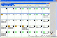
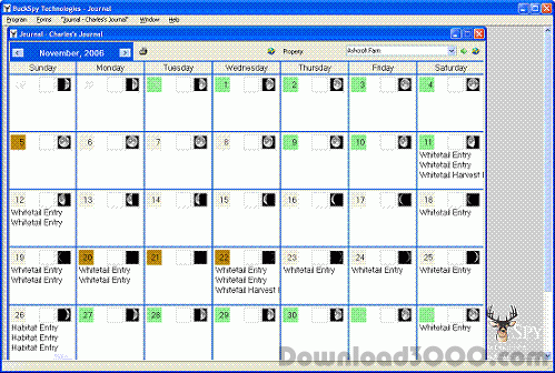
By combining the information from your hunting journal, weather and moon information, your trail camera, and now an Interactive Aerial Photo, BuckSpy has created the Ultimate Scouting Tool, BuckSpy Advanced with Mapping. Features Include the following: 2 week forecasted Hunting Report Forecasted Weather Information Moon Phases and Activity Prediction Indexes Download Aerial and Topographical Maps Overlay Topo lines on an Aerial Map Specify locations and observations on map Create Property Summary Maps Store Trail Camera Images Record Deer Harvest Data Record Deer Observations Record General Wildlife Observations Record Habitat Enhancements Record Deer Sign Record stand, camera, etc … locations Record Weather Data Create Property Summary Reports Create Property Summary Harvest Reports Ability to Check for Latest Update Create Blank Fill-Form Reports BuckSpy Advanced with Mapping is the Ultimate Hunting Journal. Isn’t it time to take your scouting to the next level?
Related Programs

Deer Hunting Expert 5.0a
Provides 100 scenarios for hunting deer
IP-Country mapping Database 2010.02
IP Address Country mapping Database
Canvas GIS Mapping Edition 9.0.4
Illustration & image editing with GIS Mapping
Graham Process Mapping 7.10.0517
Document, improve & manage business processes
Eye4Software GPS Mapping Studio 4.1
GPS Mapping Software for Windows